

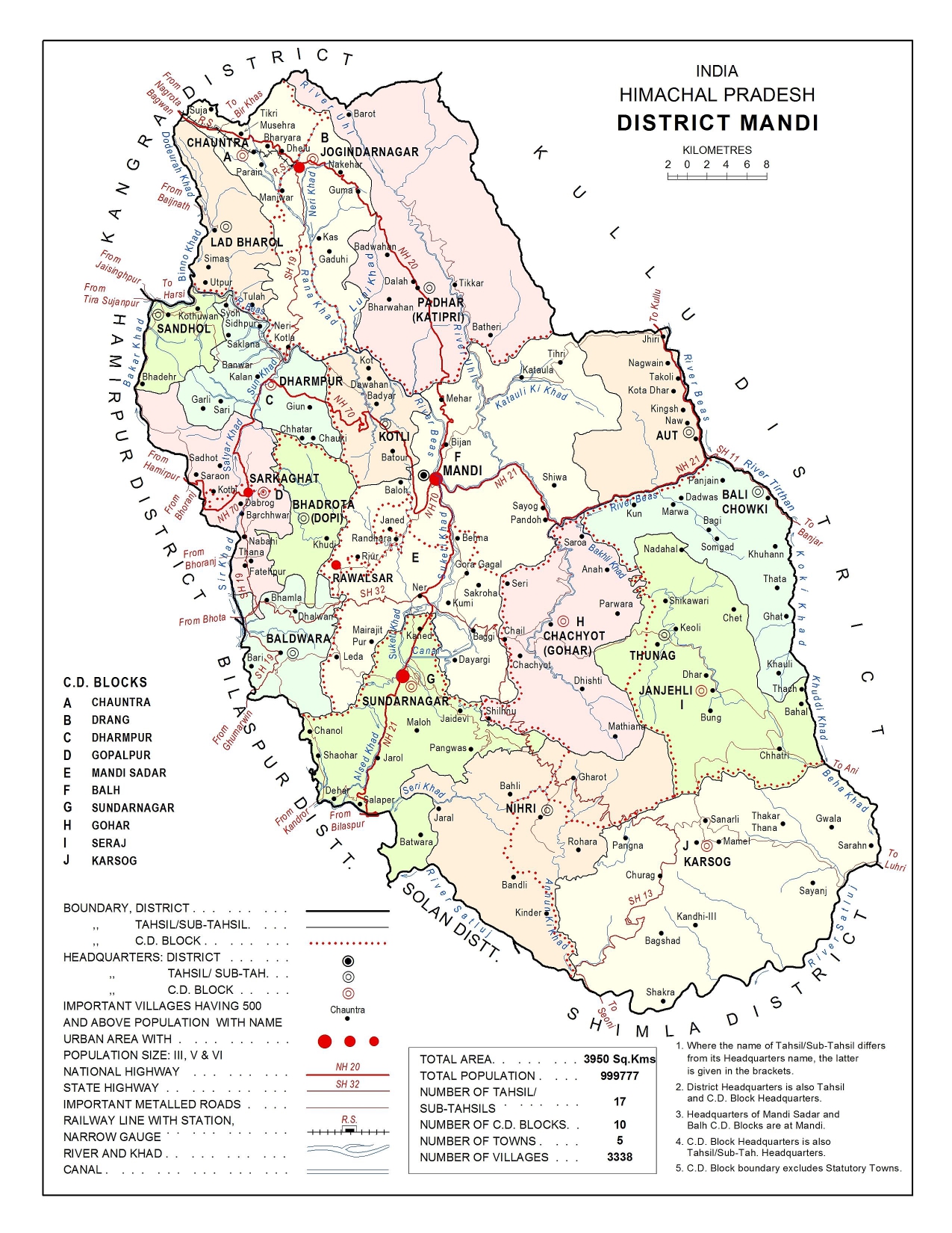
Location and size
- Mandi district falls in the central portion of Central Himachal Pradesh which is one of the four micro-regions of the State.
- It lies between 310 13′ 30′′ and 320 04′ 22′′ north latitudes and 760 36′ 08′′ and 710 23′ 26′′ east longitudes and is bounded by Kangra district in the north and north-west, Hamirpur and Bilaspur districts in the west, by Solan and Shimla districts in the south and by Kullu district in the east.
- The district has an area of 3950 km.2 out of the total area of 55673 km.2 of Himachal Pradesh according to the Surveyor General of India.
- It occupies the seventh rank among the districts in terms of area which constitutes 7.10 per cent area of the state.
- Mandi district shows a high concentration of population having 253 persons per km.2.
- It occupies the second rank among the districts with a population of 9,99,777 accounting for 15.01 per cent of the total population of the state in Census 2011.
- The district occupies the fourth position in Census 2011 as was in the 2001 Census in terms of sex-ratio which has declined from 1,013 to 1,007 females per 1,000 males.
Physiography and Drainage
- The configuration of the district is mountainous interspersed with many flat and undulating valleys formed by Beas river and its tributaries.
- Balh Valley in Mandi Sadar and Sundarnagar tehsils and Chauntra valley in Jogindarnagar tehsil are very wide and long which are the granary of the district.
- The altitude of the district varies between 503 metres and 4,034 metres above the mean sea level.
Hill Ranges/Dhars in District Mandi
Dhauladhar:
- Most part of Suket is covered with this range.
NagruNargu is the highest peak of this range in district Mandi at an altitude of around 4400 meters.
Ghogardhar: Gumma and Darang Salt mines are located in this range.
Sikandar Dhar: The name is attributed to Sikandar Lodhi. This range can be sub-divided into two ranges. Kamlah Dhar and Lindi Dhar.
Vairkot Dhar: This range starts from Rewalsar and extends towards Suket.
River System of District Mandi
River Beas:
- The Beas enters the district from the eastern side near Largi village where the Sainj and Tirthan streams join it and flows east to north-west direction.
- It leaves the district in the west near Sandhol and enters into Hamirpur district.
- Uhl, Rana Khad, Luni Khad and Binno Khad join it from north and other rivers/Khads which join it from south are Bakar, Masant, Jhangi, Chaned, Sakrain, Soan, Arnodi, Kasani, Junisuketi, Bakhli, Tirthan, and Hansa.
River Satluj:
- The river Satluj which forms its southern boundary and separates it from Solan and Shimla districts is another major river in the district.
- River Satluj enters the district near Firnu village in the Chawasigarh area and flows towards the southwesterly direction.
- It leaves the district near Dehar and enters into Bilaspur district.
- Behna, Ropri, Bagri, Chanod and Alsed etc. are important streams/khads, which fall into Satluj from the northern side.
Lakes in District Mandi
Kamrunag or Kumarwah Lake:
- It is located at an altitude of 3150 mts in Chachyot Tehsil of Mandi district.
- It is said that Lake was formed by Bhimsen one of the Pandava brother along with Devta “Kamrunag”.
- Gold and Silver offerings are thrown in this lake.
Rewalsar Lake:
- This lake is 25 km from Mandi town and is a circular lake with three quarters of a mile in diameter.
- This lake was known for its floating islands but nowadays, no floating islands can be seen there.
- The lake is also associated with Nag cult or serpent worshipping.
- Rewalsar is associated with three religious beliefs; Hindu, Buddhism, and Sikhism.
Prashar Lake:
- It lies at an altitude of 2743 mts (9000 feet) and is around 45 km from Mandi town.
- It is located in a cup-like valley and a temple in Pagoda architecture devoted to Rishi Prashar is also located here which is built by Raja Ban Sen of Mandi.
Macchial Lake:
- This lake is 2 km from Jogindernagar.
- The lake is named after one of the avatars of Vishnu, named Macchendru Devta a Matsya (Fish) Avtar of Lord Vishnu.
Pandoh Lake (Artificial Lake):
- It is 15 km from Mandi town towards Manali on NH 21.
- This lake is formed due to the construction of Pandoh dam after diverting the water of the Beas to Satluj River.
Physiographic Divisions of the District
On the basis of physiography, climate, soils, natural vegetation and geology the district is divided into four sub-micro regions of:
Dhauladhar:
- Dhauladhar extends over north and north-eastern Mandi and runs in continuation to Dhauladhar of Kangra district in the north-west to south-east direction passing through the northeastern part of Jogindarnagar tehsil, maximum parts of Padhar tehsil except a southeastern corner, the north-eastern margin of Mandi tehsil and a north-western portion of Aut sub-tehsil.
- The region is very rugged and mountainous with many snow-covered peaks of above 4,000 metres high.
- Uhl is the main river of this region with its tributaries like Jhakwan, Panchwad, Bubbu Nal, Sang Nal, Baroh Nal and Batheri khad from the left side.
Beas Basin:
- Beas basin is the biggest sub-micro-region of the district in terms of area and population.
- It stretches in a north-west to the south-east direction in the central part of the district.
- It covers the south-western corner of Padhar Tehsil, north-western, western and southern parts of Jogindarnagar tehsil, the whole of Lad Bharol, Sandhol, Bali Chowki sub-tehsils and Chachyot tehsil, maximum part of Dharmpur, Kotli and Aut sub-tehsils and Mandi tehsil, the northern part of Sundarnagar Tehsil, three villages of Nihri sub-tehsil and almost whole of Thunag tehsil except southern portion.
- It is bounded by Kullu district in the east, Dhauladhar in the north and north-east, Kangra and Hamirpur districts in the north-west, Mandi lesser Himalaya in west and Satluj Basin in the south.
- This basin is hilly with many dhars like Sikandardhar, Margholi dhar, Bhaburi dhar, Rajotu dhar, Chharyand dhar and Shikari Devi dhar etc. except valleys of Balh and Chauntra.
- Beas river is the principal river of this region.
Satluj Basin:
- The Satluj basin extends over the southern part of the district covering Sundarnagar tehsil except for northern portion, southern Thunag tehsil, the whole of Karsog Tehsil and Nihri sub-tehsil except a small northern pocket.
- It is bounded by Beas basin and Mandi Lesser Himalaya in the north, by Bilaspur district in the west and Kullu district in the east.
- The terrain is rugged and hilly with many dhars with elevation varying between 2,160 metres to 3,124 metres.
- Satluj river is the life belt of the basin which forms the southern boundary of the district and separates it from Shimla and Solan districts.
Mandi Lesser Himalaya:
- The Mandi Lesser Himalaya spreads over the western part of Mandi district occupying the whole of Baldwara sub-tehsil, Bhadrota sub-tehsil and Sarkaghat tehsil, the southern part of Dharmpur sub-tehsil, southwestern part of Kotli sub-tehsil, the western part of Mandi tehsil and small central track of Sundarnagar tehsil.
- It makes its boundary with Beas basin in north and east, Satluj basin in south and Bilaspur and Hamirpur districts in the west.
- The terrain of this region is rugged and hilly with altitude ranging between 682 metres to 2,051 metres above the mean sea level.
- The important rivulets of the region are Baker, Sir, Son and Ratti Khads.
The Climate of District Mandi
- The district being mountainous, the climate is temperate.
- In upper areas, the climate remains cold throughout the year.
- The areas of Padhar, Chohar, Seraj and Sonar usually experience sufficient snowfall during winter which often comes down to 1,300 metres altitudes.
- In summer, other low areas and Balh valley are quite hot.
- The Satluj basin experiences excessive hot months near the south-east border.
- Tatapani and Dehar are the hottest places in the district.
- The sub-temperate climatic conditions prevail in Dhauladhar micro sub-region, as it is a mountainous track.
- Higher reaches of the region receive sufficient snowfall every year during winter and remain cut off from the other parts of the district.
- The lower areas are comparatively hot. The climatic conditions of the higher reaches of Beas basin are temperate.
- In winter these areas receive snowfall almost every year where the weather remains cool throughout the year.
- Lower areas are comparatively hot during the summer.
- Month of July and August receive the heaviest rainfall in this region.
- The climatic conditions of the Satluj basin vary according to altitude.
- Summers are warm in lower areas and high altitude areas are cooler. In winter, upper areas of Nihri, Thunag and Karsog receive snowfall every year.
- Rainfall is mostly received during the monsoon months.
- In Mandi Lesser Himalaya, the climate is mild during winter in upper areas whereas lower altitudes are hot in summer.
- The district receives an ample and uniformly distributed rainfall.