Category Archives: Geography of HP

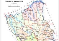
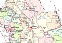
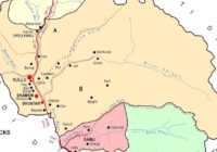
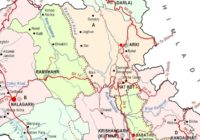
Brief Geography of District Una – Himachal Pradesh

By | July 4, 2020

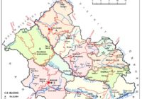
Physical features Una district lies in the south-western part of Himachal Pradesh. It is bounded by Kangra district in the north and north-east, Hamirpur district in the east, Bilaspur in the south-east and Punjab State in west and south. The district is stretched between 31°17′52″ – 31°52′0″ north latitudes and 75°58′21″ – 76°28′25″ east longitudes.… Read More »

Brief Geography of District Hamirpur – Himachal Pradesh

By | June 23, 2020

Physical features of District Hamirpur The district is located in the south-western part of the state. It forms a part of central Himachal Pradesh and is situated predominantly in outer Himalaya or Shiwalik Zone. It lies between 310 24′ 48″ and 310 53′ 35″ north latitudes and 760 17′ 50″ and 760 43′ 42″ east… Read More »

Brief Geography of District Mandi – Himachal Pradesh

By | June 15, 2020

Location and size Mandi district falls in the central portion of Central Himachal Pradesh which is one of the four micro-regions of the State. It lies between 310 13′ 30′′ and 320 04′ 22′′ north latitudes and 760 36′ 08′′ and 710 23′ 26′′ east longitudes and is bounded by Kangra district in the north… Read More »

Brief Geography of District Kullu – Himachal Pradesh

By | June 9, 2020

Location and size Kullu district is located in the eastern part of central Himachal Pradesh. The district lies between 31020′ 25” to 320 25′ 0″ north latitude and 760 56′ 30″ to 770 52′ 20″ east longitude. It is bounded on the north and east by Lahaul & Spiti district, on the south-east by Kinnaur… Read More »

Brief Geography of District Solan – Himachal Pradesh General Studies

By | June 2, 2020

District At a Glance Area: 1936 Sq. Km. Population: 5,80,320 Language: Hindi, Pahari Villages:  2614 Male: 308754 Female: 271566 Location: The District is bounded by Shimla district in the North and by Ropar District of Punjab and Ambala district of Harayana in the south, by Sirmaur District in the east and by Bilaspur district in the west. Mandi District touches the boundary… Read More »

Brief Geography of District Sirmaur – Himachal Pradesh General Studies

By | May 25, 2020

Size and Location: The district lies in outer Himalaya (Shivaliks) except the “Dun valley” which is called “Kayar-Da-Dun”. Sirmaur district falls in the south-eastern parts of Himachal Pradesh which constitutes a part of the southern Himachal Pradesh of Himachal Pradesh Himalaya region. The district is further sub-divided into four sub-micro regions of the Upper Sirmaur… Read More »

Churdhar Peak – District Sirmaur of Himachal Pradesh

By | May 24, 2020

Churdhar is a beautiful place in the Sirmaur district which is basically famous for the temple of Lord Shiva’s. Churdhar or Chur-Chandni is a solitary peak that literally means ‘moonlight gleaming on the snow’. Here in this place there is a Shiv Ling, which is believed to be the religious Ling. The name of the place is derived from… Read More »

Brief Geography of District Shimla – Himachal Pradesh General Studies

By | May 19, 2020

Shimla district forms a part of southern Himachal Pradesh. The district lies between the longitudes 76°59’22” and 78°18’40” east and latitudes 30°45’48” and 31° 43’0″ north and is bounded by Mandi and Kullu district in the north, Kinnaur in the east, the state of Uttarakhand and Sirmaur district in the south and by Solan district… Read More »