Category Archives: Geography of HP

Minerals Wealth Found in Himachal Pradesh

By | May 2, 2020

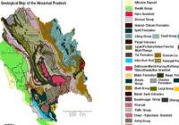
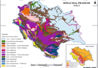
Himachal Pradesh is endowed with several important minerals like limestone, high-grade limestone, quartzite, gold, pyrites, copper, rock salt, natural oil and gas, mica, iron ore, etc. and is the only state in India where rock salt is mined. Major Minerals found in Himachal and their district wise distribution. Hamirpur – Sand, Stones Bilaspur Limestone, Shale… Read More »

Classification/Type of Forests in Himachal Pradesh

By | May 2, 2020

Forests constitute an important natural resource of the state, which provides timber, fuel, fodder, wood, timber, herbs, house construction, packaging of the horticultural produce and in agricultural implements, medicinal plants, etc. The forests contribute 1/3 of the total revenue of the state and also provide employment to a sizable population. Distribution of various species is… Read More »

Brief Geography of District Lahaul-Spiti

By | April 26, 2020

The district Lahaul-Spiti lies between 31°44’55” and 32°59’57” North latitude and 76°46’29” and 78°41’34” East longitude. It is bordered in the north by Jammu and Kashmir, Tibet in the east and Kullu and Kinnaur in the south-east and Chamba in south-west and west. The district is surrounding by high mountains on all sides, the great… Read More »

Brief Geography of District Kinnaur

By | April 21, 2020

The District Kinnaur is situated 77°45’ and 79°00’35” East Longitude and between 31°55’50” and 32°05’15” North Latitude. Kinnaur is located in the North-Eastern part of Himachal Pradesh. Kinnaur shares the Eastern border with Tibet and Zanskar mountains and forms the international boundary between Tibet and Kinnaur. The border starts at a point named “Parechhu” and… Read More »

Brief Geography of District Bilaspur

By | April 15, 2020

Location of District Bilaspur: The geographical area of the district is 1167 Sq. kms which cover 2.1% area of the state. The district lies between north latitude 31012’30’’ and 31035’45’’ and east longitude 76023’30’’ and 76055’40’’. It is predominately situated in the lower Satluj valley in the outer hills. District Bilaspur lies exclusively in the Shiwalik… Read More »

Geography of District Chamba

By | April 9, 2020

Mountain Ranges in District Chamba:  Hathi Dhar (Snowless range): The low range of Hills called Hathi Dhar runs parallel to the south of Dhauladhar. It is the inner ridge of Shivalik range. The Pangi Range: This range is called Pir Panjal by geologists and Pangi Range by common people. It is a continuation of main… Read More »

Brief Detail of the Geography of District Kangra

By | April 8, 2020

Note: This article is written from an exam point of view only.  Kangra district is bounded on the North by Lahaul-Spiti and Chamba, South by Hamirpur, East by Kullu and Mandi, South-West by Una, and North-West by Gurdaspur (Punjab). The total area of Kangra district is 5739 sq. Km (10.31%) of the state, ranks fourth… Read More »

Types of Soil in Himachal Pradesh

By | March 31, 2020

The naturally occurring thin layer of unconsolidated material on the earth surface that has been influenced by parent material, relief, climate, in addition to physical, chemical, biological agents to produce a medium, suitable for the growth of the plants is called soil. Soil exhibits differences in their physical and chemical characteristics as well as in… Read More »