

District At a Glance
-
Area: 1936 Sq. Km.
-
Population: 5,80,320
-
Language: Hindi, Pahari
-
Villages: 2614
-
Male: 308754
-
Female: 271566
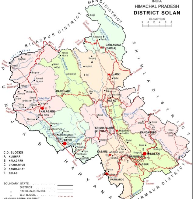
Location: The District is bounded by Shimla district in the North and by Ropar District of Punjab and Ambala district of Harayana in the south, by Sirmaur District in the east and by Bilaspur district in the west. Mandi District touches the boundary of Solan district in the north-east.
The total area of the district is 1,936 sq kms forming 3.5 percent of the total area of the State. This district is divided into four sub-micro regions of Satluj Basin, Solan Lesser Himalaya, Nalagarh Shiwalik, and Solan Forests.
The shape of the district is rectangular with a slight bulge on the northern side intruding towards Mandi district.
It is located between the longitudes 76.42 and 77.20 degrees and latitudes 30.05 and 31.15 degrees north. the elevation of the district ranges from 300 to 3,000 meters above sea level.
Physiography: The terrain of the district, on the whole, is mountainous except three valleys of Kunihar in Arki, Saproon in Solan, and Doon in Nalagarh tahsil.
Doon valley is the most fertile and is bigger in size, whereas Kunihar and Saproon valleys are smaller.
River System:
Solan district is the catchment area of three important rivers of Satluj, Yamuna, and Ghagghar.
Tributaries of Yamuna: Ashni
Tributaries of Satluj: Kiar ka Nala, Ghandhar river, Dadar Khad and Kuthar Nadi etc.
Tributaries of Ghaggar: The tributaries of Ghagghar river is Kaushlya, Sirsa Nadi is the mainstream in Nalagarh which has its source in the hills above Kalka and runs north-west along the base of the Shiwalik eventually joining Satluj river at Avankot in Ropar district of Punjab.
Ghambar Khad: Ghambar river is a rain fed river. Dabar, Kuthar, Kohaj are its right bank tributaries and Rao, Kuni and Badhal khads are its left bank tributaries.
Sirsa Nadi: Sirsa nadi is the important river of Nalagarh Shiwalik region. Balad nadi, Ralla nadi, Phula nala and Chikni khad are the tributaries of Sirsa nadi.
District Headquarters
Solan is the district headquarters of Solan district (created on 1 September 1972) in the state of Himachal Pradesh. The largest Municipal Council of Himachal Pradesh, it is located 46 kilometers south of the state capital, Shimla. At an average elevation of 1,600 metres (5,200 ft). The place is named after the Hindu goddess Shoolini Devi. Every year in the month of June, a fair celebrating the goddess is held, featuring a 3-day mela at Thodo ground. Solan was the capital of the erstwhile princely state, Baghat.
It is known as the “Mushroom city of India” because of the vast mushroom farming in the area as well as the Directorate of Mushroom Research (DMR) situated at Chambaghat.
Solan is crowned as the “City of Red Gold“, in reference to the bulk production of tomatoes in the area The town is situated between Chandigarh and Shimla, on the Kalka-Shimla National Highway. The Kalka-Shimla narrow gauge heritage railway line, built by the British passes through Solan and is a recognized World Heritage site.