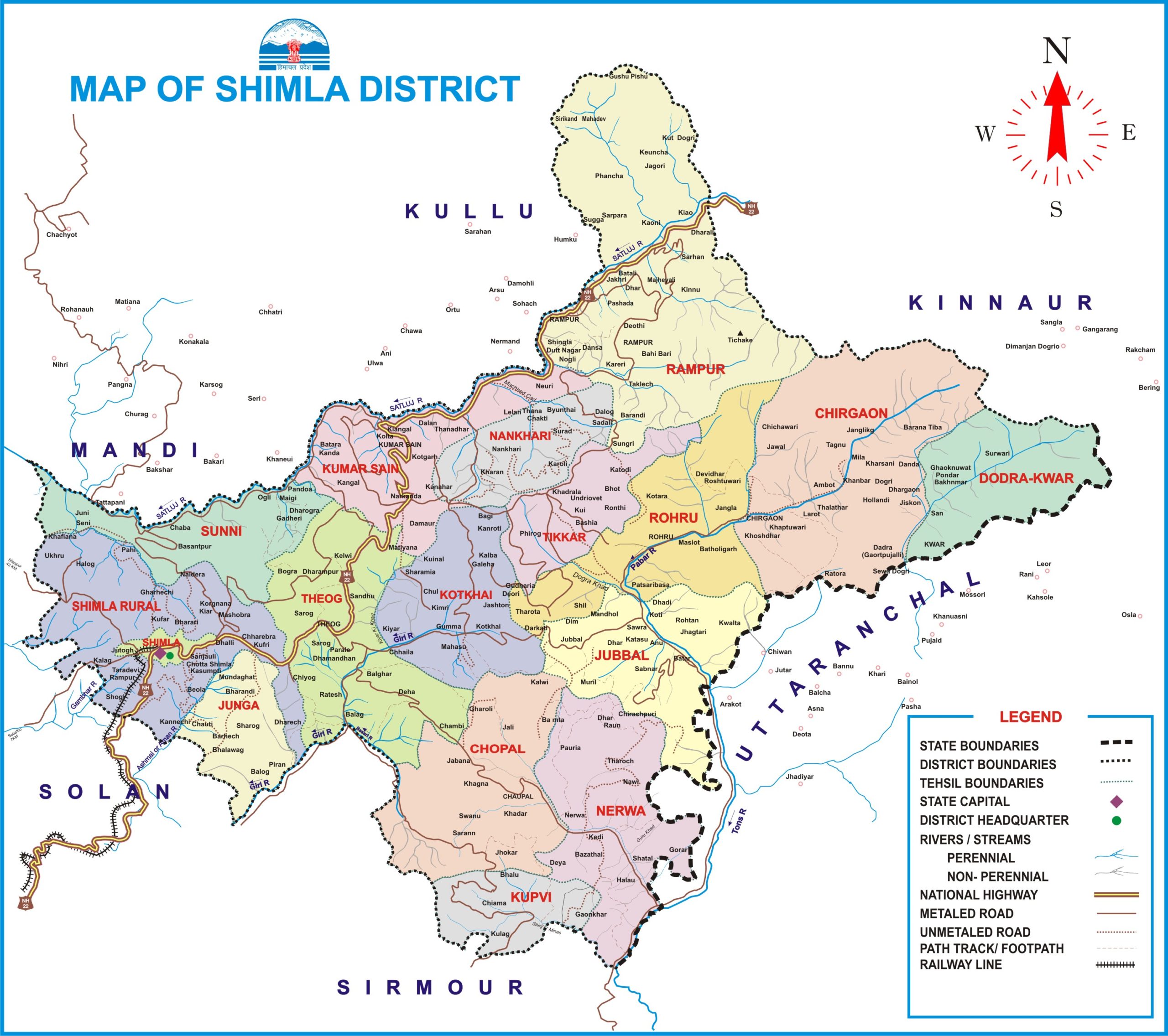
Shimla district forms a part of southern Himachal Pradesh. The district lies between the longitudes 76°59’22” and 78°18’40” east and latitudes 30°45’48” and 31° 43’0″ north and is bounded by Mandi and Kullu district in the north, Kinnaur in the east, the state of Uttarakhand and Sirmaur district in the south and by Solan district in the west.
The elevation of the district ranges from 300-6,000 meters.
The average rainfall of District Shimla is 1028 mm.
The district has an area of 5,131 sq. km out of a total area of 55,673 sq. km. of Himachal Pradesh according to the Surveyor General of India.
Famous peaks in Shimla district:
- Choordhar in Tehsil Chaupal
- Shali in Sunni Tehsil
- Jakhoo in Shimla town
- Siah near Chail
- Chansal in Rohru Tehsil
- Haatu in Kumharsain
Read also: Peaks in Himachal Pradesh
Rivers in District Shimla
River Satluj:
- River Satluj after flowing through the district Kinnaur enters district Shimla at “Badhal” in Rampur Tehsil.
- Satluj forms the boundary of district Shimla with Nirmand and Anni Tehsil of Kullu and Karsog Tehsil of district Mandi.
- River Satluj leaves district Shimla at Sunni Tehsil.
- The main tributaries of Satluj in district Shimla are Nogli, Machhada, Bhaira, Kingal, and Khekhar, Chamola, Savera and Bagh nullahs, etc.
Read also: River System of Himachal Pradesh
River Giri Ganga:
- It originates from the “Kupar” peak. Ashani (Ashwani Khad) is the main tributary of River Giri.
- The river collects the drainage of the whole tract of Churdhar and the Shimla range.
- The principal feeder of the Giri is Ashni Khad which rises near Mahasu in the Shimla range and after receiving a considerable contribution from the eastern face of the hill upon which the Shimla town stands, joins the Giri at a point where the river turns south-east.
- Shimla town is built upon this river.
River Pabbar:
- It rises from the base of the Chandranahan peak in Rohru tehsil.
- It flows through Rohru, Jubbal, and merges with River Tons at Tiuni in Uttrakhand.
- The main tributaries of River Pabbar are Shikri, Andhra, Pejore, Hathkoti, etc.
Read also: Important Historical Buildings in Shimla
Lakes in District Shimla:
- Tani Jubbar Lake
- Chandranahan Lake
- Karali Lake
The Geological Structure of Shimla:
- The geological structure of the district is mainly composed of the Jutogh group.
- However, small tracts of Krol series, Nagtha group, Shimla group, Rampur-Banjar formations, Shali-Deoban, and Granites (unclassified) are also observed in the district.
- The soil’s texture varies from light sandy to heavy clay. In the deep valleys and basins, it is generally sandy and sandy loam.
- The soil of the district as classified by the N.B.S.S. and L.U.P. (I.C.A.R.) Nagpur contains mainly Orthents– Ochrepts type of soil cover.
- However, in the eastern, southern, and western extremes, the soils are categorized as Udalfs, Udalfs-Orchepts, and Orchepts-Orthents.
- The extreme north of the district has a glacier and snowcapped types of soil cover.
Geology: According to the study of the rocks by the geologists it is revealed that some 1,200-1,500 million years ago the area comprising the present Shimla district was a part of the sea called Tethys.
Minerals found in district Shimla:
Alump: Limestone, quartzite, slabs, barytes lead, and byrite are found in the district but these minerals are not of commercial significance except limestone and slabs slate.
Gold: Alluvial gold in the Himalayan rivers is a common feature. Alluvial gold is reported to occur at Chirgaon (31° 32’: 78° 6’) near Urni but it is not of economic importance.
Iron Ore: Hematite iron ore banded as well as lense like in character is found in Rohru.
Iron-pyrite: In the Keonthal area and to the south of Shimla, general lenticular bands of iron pyrites occur slates of Bio-leaugunge stage of the Jutogh series.
Iron pyrite is recorded from the following localities:
- Kyari (Shamri) Nala
- Badhaighat
- North of Rehana
- South of Chhota Shimla
Kyanite: It is abundant in the schists and granites near parts of Bushahr in the western Himalayas.
Limestone: Occurrences of limestone deposits are reported from Naldehra and Basantpur in the district. A portion of these deposits may be of cement grade.
Slates: These are quarried at many places in the outer Himalayas of Shimla Hills.
Other info:
People in Bushar mainly in Kinnaur and Kotgarh area speak Kochi dialect.