The State of Himachal Pradesh has a geographical area of 55,673 sq km, which constitutes 1.69% of the geographical area of the country. The State lies between 30º22’N to 33º12’N latitude and 75º45′ E to 79º04′ E longitude and is bordered by Jammu & Kashmir in the North, Punjab in the West, Haryana in the South and Uttarakhand in the Southwest.
The State has an international border with China in the East. Predominantly a mountainous State in the western Himalayas, the State has three distinct regions viz the Shiwaliks with altitude upto 1,500 m, middle Himalayan region between 1,500 m to 3,000 m and the Himadris higher than 3,000 m. About one-third of the area in the State is permanently under snow, glaciers and cold desert. The tree growth is minimal in this region due to harsh conditions.
The average annual rainfall is about 1,800 mm. The temperature varies from sub-zero to 35°C. The Satluj, Beas, Ravi, Chenab and Yamuna are the important rivers of the State. The State has 12 districts all of which are hill districts. There are three tribal districts.
As per the 2011 census, Himachal Pradesh has a population of 6.86 million accounting for 0.57% of India’s population. The rural and urban population constitutes 89.97% and 10.03% respectively. Tribal population is 5.71% of the State’s population.
The population density of the State is 123 per sq km which is much lower than the national average. The 19th livestock census 2012 has reported a total livestock population of 4.84 million.
A Brief Overview of Forestry Scenario:
As per the Champion & Seth Classification of Forest Types (1968), the forests in Himachal Pradesh belong to eight Type Groups which are further divided into 39 Forest Types. The forests in the State can be broadly classified into coniferous forests and broad-leaved forests. Distribution of species follows altitudinal zonation.
The vegetation varies from dry scrub forests at lower altitudes to alpine pastures at higher altitudes. In between these two extremes, distinct vegetational zones of Mixed Deciduous Forests, Bamboo, Chir Pine, Oak, Deodar, Kail, Fir and Spruce are found. More than 95 species are endemic to Himachal Pradesh and characteristic of Western Himalayan flora, while about 5% (150 species) are exotic, introduced over the last 150 years. The State Government aims at bringing 50% of the geographical area under forest cover. Being a forest fire sensitive State, a detailed standard operating procedure called ‘HP Forest Fire Manual – Prevention and Control’ has been published by the State in 2018.
Recorded Forest Area (RFA) in the State is 37,033 sq km of which 1,898 sq km is Reserved Forests, 33,130 sq km is Protected Forests, and 2,005 sq km Unclassed Forests. In Himachal Pradesh, during the period 1st January 2015 to 5th February 2019, a total of 959.63 hectares of forest land was diverted for non-forestry purposes under the Forest Conservation Act, 1980 (MoEF&CC, 2019).
The Protected Area Network in the State has five National Parks, 28 Wildlife Sanctuaries and three Conservation Reserves, which cover 15.10% of the geographical area of the State.
Forest Cover:
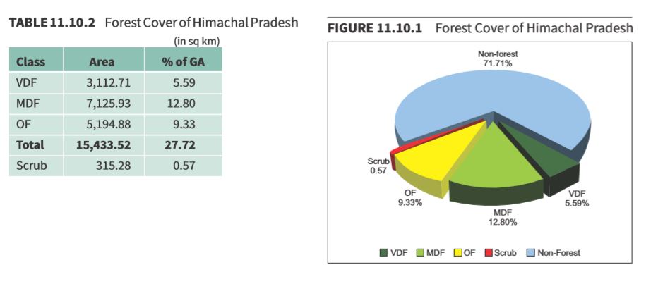
Based on the interpretation of IRS Resourcesat-2 LISS III satellite data of the period Oct to Dec 2017, the Forest Cover in the State is 15,433.52 sq km which is 27.72% of the State’s geographical area. In terms of forest canopy density classes, the State has 3,112.71 sq km under Very Dense Forest(VDF), 7,125.93 sq km under Moderately Dense Forest (MDF) and 5,194.88 sq km under Open Forest (OF). Forest Cover in the State has increased by 333.52 sq km as compared to the previous assessment reported in ISFR 2017.
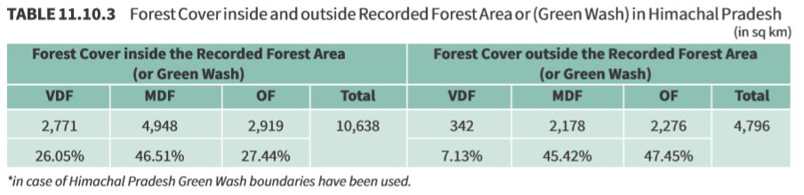
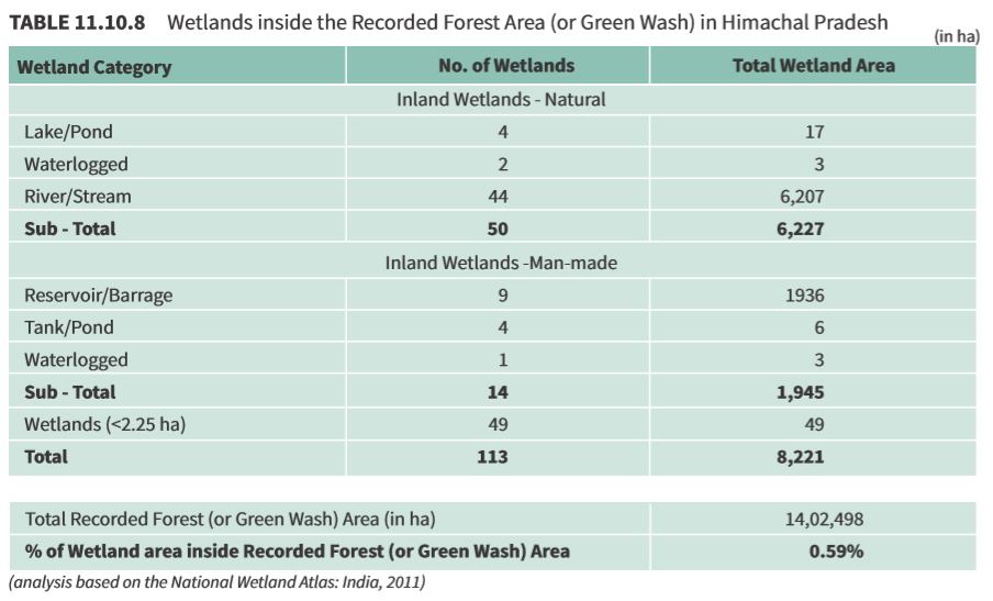
Forest Cover inside and outside Recorded Forest Area (or Green Wash):
The State has reported extent of of recorded forest area (RFA) 37,033 sq km which is 66.52% of its geographical area. The reserved, protected and unclassed forests are 5.13%, 89.46% and 5.41% of the recorded forest area in the State respectively. Due to non-availability of digitized boundary of recorded forest areas from the State, the updated Green Wash from SoI toposheets which is 14,024.98 sq km has been used as proxy to the RFA boundary and the analysis of forest cover inside and outside this area is given below.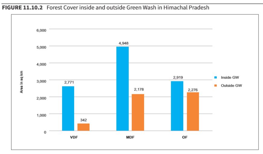
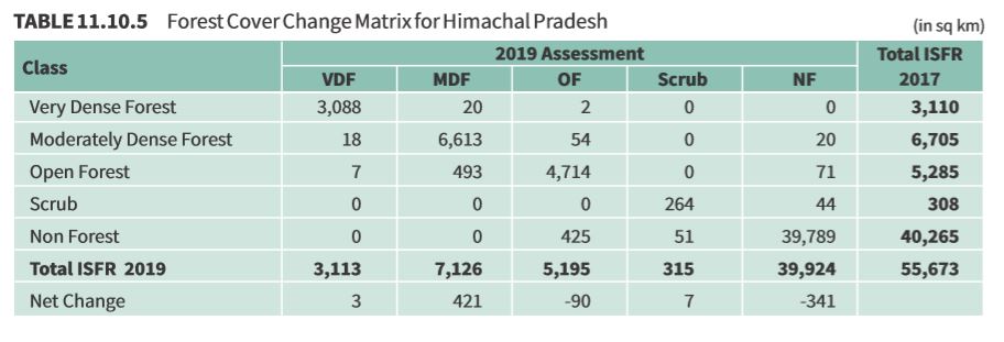
Main reasons for the increase 333.52 sq km in forest cover in the State are plantation and conservation activities.
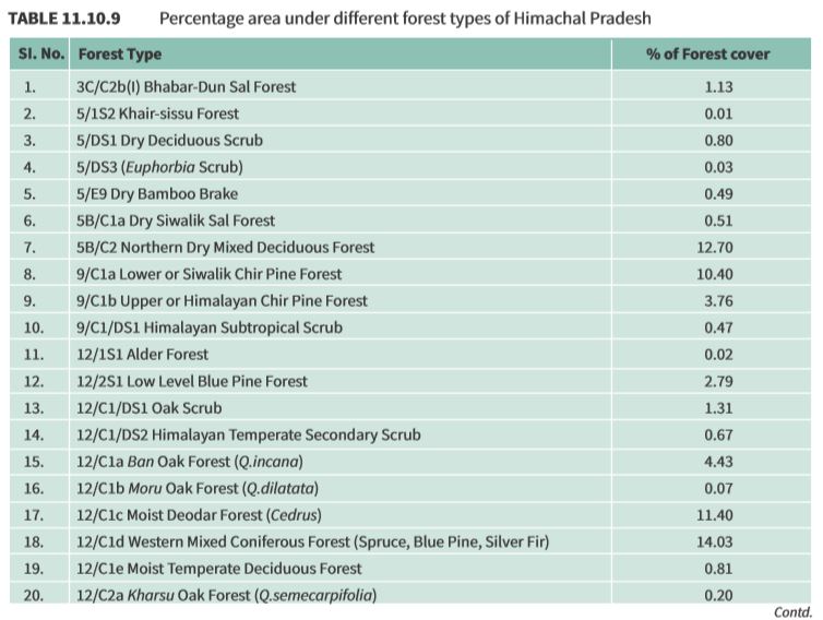
Forest Types & Biodiversity:
Forest Type Maps of 2011 have been refined in the recently completed exercise by FSI. Percentage area under different forest types of Himachal Pradesh as per the Champion & Seth classification (1968), according to the latest exercise are presented in the following table.
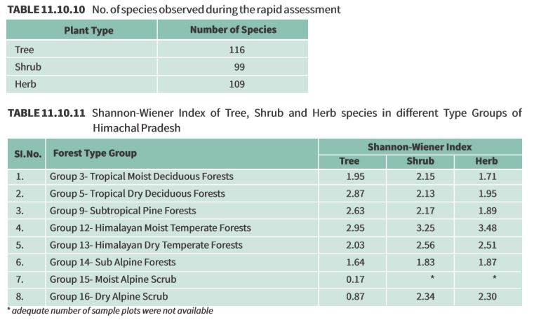
Assessment of Biodiversity:
Findings of the rapid assessment of Biodiversity carried out at the national level for natural forests during September 2018 to May 2019 as part of the forest type mapping exercise is summarized below in table 11.10.10 and table 11.10.11 in respect of Himachal Pradesh.
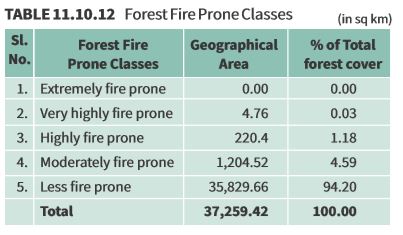
Fire-Prone Forest Areas:
Tree Cover:
Forest cover presented in the section 11.10.2 accounts for tree patches of size 1 ha and more having canopy density more than 10%. However, trees occurring in patches of size less than 1 ha including scattered trees are assessed through sampling based methodology. Tree cover in Himachal Pradesh has been estimated as given in table 11.10.13.
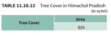
Tree cover of Himachal Pradesh has increased by 7 sq km as compared to the previous assessment reported in ISFR 2017.
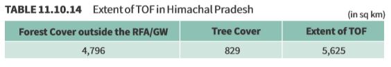
Extent of Trees Outside Forest (TOF):
Trees outside Forests (TOF) refer to tree resources found outside the forests as defined in the Government records. FSI maps forest cover using satellite data and assesses tree cover outside forests using sampling based method. Forest Cover outside the recorded forest area is derived using boundaries of RFA or Green Wash. Extent of TOF therefore may be estimated as the sum of extent of forest cover outside the recorded forest areas (RFA) and tree cover as given in the preceding section.
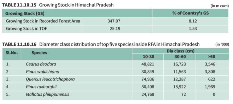
Growing Stock in Forest:
Growing stock in the recorded forest areas (RFA) in Himachal Pradesh is given in the table 11.10.15. Diameter class-wise distribution of top 5 species in numbers derived from the forest inventory data is presented in the table 11.10.16
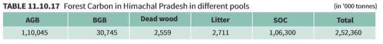
Carbon Stock in Forest:
The total Carbon stock of forests in the State including the TOF patches which are more than 1 ha in size is 252.36 million tonnes ( 925.32 million tonnes of CO equivalent) which is 3.54% of total forest carbon 2 of the country. Pool wise forest carbon in Himachal Pradesh is given in the following table
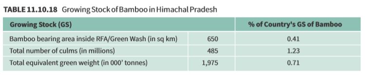
Growing Stock of Bamboo:
Bamboo bearing area and growing stock inside the recorded forest area (RFA)/ Green Wash in the State which include culms of 1 year age and above are given in the table 11.10.18
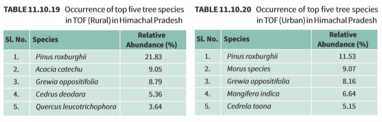
Dominant tree species in Trees Outside Forests (TOF):
Top five species in numbers in Trees Outside Forests in Himachal Pradesh in Rural and Urban areas are given in the table 11.10.19 and table 11.10.20 respectively
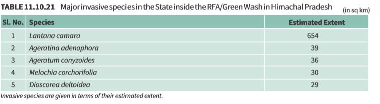
Invasive Species:
Invasive species as assessed from forest inventory data are presented in table 11.10.21.
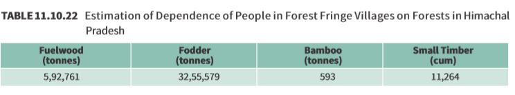
Quantified estimation of Dependence of People living in forest fringe villages on forests in Himachal Pradesh:
Through a nation-wide study, FSI has done estimation of the dependence of people living in the villages close to the forest for fuelwood, fodder, small timber, and bamboo in quantified terms for each State & UT of the country (Please refer to Chapter 10 in Vol. I for details). The estimated quantities of the four produce for Himachal Pradesh is given in the table 11.10.22