Hazard Vulnerability of Himachal Pradesh
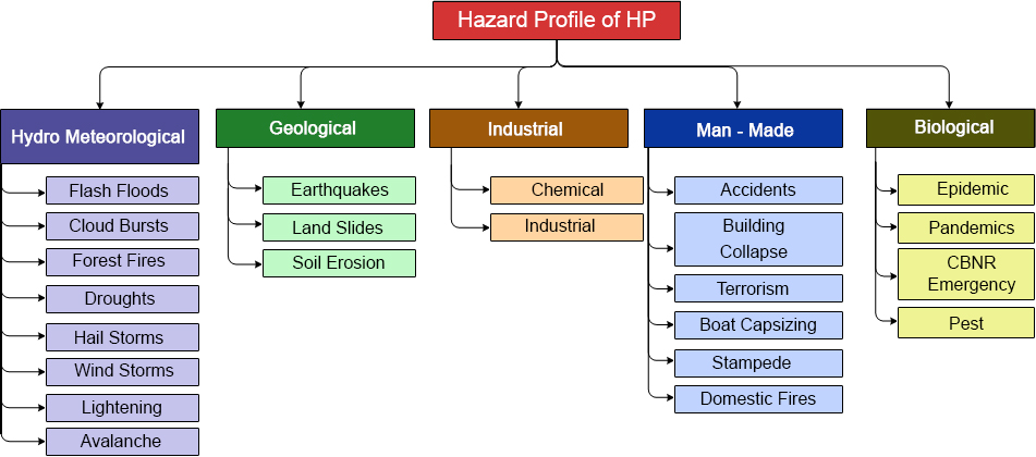
The state of Himachal is prone to various hazards both natural and manmade. Main hazards consist of earthquakes, landslides, flash floods, snowstorms and avalanches, draughts, dam failures, fires – domestic and wild, accidents – road, rail, air, stampedes, boat capsizing, biological, industrial and hazardous chemicals, etc. The hazard which, however, poses biggest threat to the State is the earthquake hazard. The State has been shaken by more than 80 times by earthquakes having a magnitude of 4 and above on the Richter Scale as per the recorded history of earthquakes. As per the BIS seismic zoning map, five districts of the State, namely Chamba (53.2%) Hamirpur (90.9%), Kangra (98.6%), Kullu (53.1%), Mandi (97.4%) have 53 to 98.6 percent of their area liable to the severest design intensity of MSK IX or more, the remaining area of these districts being liable to the next severe intensity VIII. Two districts, Bilaspur (25.3%) and Una (37.0%) also have substantial areas in MSK IX and rest in MSK VIII. The remaining districts also are liable to intensity VIII.
Unfortunately, in spite of the probable maximum seismic intensities being high , the house types mostly fall under Category A, consisting of walls of clay mud, unburnt bricks or random rubble masonry without any earthquake resisting features. Now all such houses are liable to total collapse if intensity IX or more actually occurs in the future and will have severe damage called “destruction” with very large cracks and partial collapses even in Intensity VIII areas. Also, the burnt-brick houses, classified as Category B, as built-in Himachal Pradesh do not have the earthquake resisting features, namely good cement mortar seismic bands, and roof typing, etc. therefore, they will also be liable to severe damage under intensity IX as well as in VIII whenever such an earthquake would occur. This became quite evident even in M 5.7 Dharamshala earthquake of 1986.
Another form of the natural hazards in the state is the frequent occurrences of landslides. The hills and mountains of Himachal Pradesh are liable to suffer landslides during monsoons and also in high intensity earthquakes. The vulnerability of the geologically young and not so stable steep slopes in various Himalayan ranges, has been increasing at a rapid rate in the recent decade due to inappropriate human activity like deforestation, road cutting, terracing and changes in agriculture crops requiring more intense watering etc. Although widespread floods problems do not exist in the state because of topographical nature, continuing attention is necessary to reduce flood hazards in the state, more particularly the flash flood hazard the incidences of which are increasing causing large scale damage. Besides, with the increase of road connectivity and number of vehicles plying on these roads in the State, the number of road accidents and loss of precious human lives is increasing day by day.
The forests of Himachal Pradesh are rich in vascular flora, which forms the conspicuous vegetation cover. Out of total 45,000 species of plants found in the country as many as 3,295 species (7.32%) are reported in the State. More than 95% of species are endemic to Himachal and characteristic of Western Himalayan flora, while about 5% (150 species) are exotic introduced over the last 150 years. Over the years the forest wealth of the State is being destroyed by the incidences of fire attributed to both anthropogenic and other reasons. The destruction of rich flora and fauna of the State due to forest fires will have serious repercussions on the ecological balance of the State. Besides, domestic fire incidents cause loss of property every day.
The State is known as land of Gods. Many famour temples are located in the State such as Sri Naina Devi, Baba Balak Nath, Sri Chintpurni, Ma Jawalaji, Ma Braheswari and Sri Chamunda Nandikeshwari Dham to name a few. Large number of devotees throng these places every year. A human stampede at the temple of Naina Devi occurred on 3 August 2008. 162 people died when they were crushed, trampled, or forced over the side of a ravine by the movement of a large panicking crowd. Possibility of such instances is always there if there is any laxity on the part of the management.
The State has three airports and more than 205 helipads/helicopter landing sites in the State. Punjab governor Surendra Nath and nine members of his family were killed when the government’s Super-King aircraft crashed into high mountains in bad weather on July 9, 1994 in Himachal Pradesh. Mr. Nath was then acting Himachal governor also. Himachal has also one ropeway near Parwanoo which witnessed accidents few years back. More ropeways are in the offing in the state. Besides, paragliding activities also take place in Bir Biling every year. Accidents have also taken place during this activity.
Hundreds of people are killed and many more injured in road accidents every year. Few parts of State have rail network also. That makes the state prone to rail accidents too. Pong, Bhakara and Chamera are the three large water reservoirs in the State. These reservoirs besides other river courses are used in the state for transportation purpose also. There is always possibility of boat capsizing during these transport activities. The cases of drowning and washing away in rivers/streams are very common in the State. Cases of snakebite and electrocution are significant during monsoon season.
The diagrammatic representation of hazard profile of Himachal is as under:
As per the BIS seismic zonation map, Himachal Pradesh falls in Zone IV and V. And five districts, namely Chamba (53.2%) Hamirpur (90.9%), Kangra (98.6%), Kullu (53.1%), Mandi (97.4%) have 53 to 98.6 percent of their area liable to the severest design intensity of MSK IX or more, the remaining area of these districts being liable to the next severe intensity VIII. Two districts, Bilaspur (25.3%) and Una (37.0%) also have substantial areas in MSK IX and rest in MSK VIII. The remaining districts also are liable to intensity VIII. Besides, the earthquake, the people of HP are also affected by landslides, avalanches, flash floods, floods, fires – domestic and wild, and droughts. Monsoon season brings all the hazards associated with it such as cloud burst, flash floods, landslides, etc. There is a huge loss of life and property every year.
Earthquake Hazards
From seismicity point of view, the state of Himachal Pradesh which forms a part of NW Himalayas is very sensitive. During the last century the state has been shaken by a number of micro as well as macro earthquakes. A number of damaging earthquakes has struck the state and the adjoining parts of Punjab,U.P. and J& K. Some of the prominent earthquakes that rocked the state are Kangra earthquake 1905(M=8.0) in which 18,815 people were killed, Kinnaur earthquake 1975 (M=6.7) in which 60 people lost their lives and Dharamshala earthquake 1986 (M5.7). Besides these major earthquakes the state has been rocked by about 250 earthquakes with magnitude 4.0 and 62 earthquakes with magnitude more than 5.0 . As per the earthquake hazard map of state , the areas falling in districts Chamba, Kangra, Mandi, Kullu, Hamirpur Bilaspur are very sensitive as they fall in Very High Damage Risk Zone (MSK IX or More) i. e. Zone V, where as the rest of the areas falls in High Damage Risk Zone (MSK VIII). Some of the major devastating earthquake that have rocked the state during the last century are as per table below.
Most Severe earthquakes in Himachal Pradesh:
| Date | Locations Affected | Magnitude | Damage |
| 4th April 1905 | Kangra | 7.8 | 20,000 people died 53,000 domestic animals perished 1,00,000 houses destroyed Economic cost of recovery 2.9 million rupees |
| 1st June 1945 | Chamba | 6.5 | NA |
| 19th January, 1975 | Kinnaur | 6.8 | 60 people died 100 badly injured 2000 dwellings devastated 2500 people rendered homeless |
| 26th April 1986 | Dharamshala | 5.5 | 6 people died Extensive damage to buildings Loss estimated at 65 crore |
| 1st April 1994 | Chamba | 4.5 | |
| 24th March 1995 | Chamba | 4.9 | Fearsome shaking More than 70% houses developed cracks |
| 29th July 1997 | Sundernagar | 5 | Damage to about 1000 houses |
Landslides Hazards
Another form of the natural hazards in the state is the occurrences of landslides. The hills and mountains of Himachal Pradesh are liable to suffer landslides during monsoons and also in high intensity earthquakes. The vulnerability of the geologically young and not so stable steep slopes in various Himalayan ranges, has been increasing at a rapid rate in the recent decade due to inappropriate human activity like deforestation, road cutting, terracing and changes in agriculture crops requiring more intense watering etc.
Landslides are known to pay havoc causing death and destruction. In India, Western and Eastern Ghats, Jammu and Kashmir, Himachal Pradesh, Uttranchal and North Eastern Parts as well known for landslides. Delineation of landslide-prone areas requires a large data set. Various forms of landslides are slumps; debris or rock slides, debris falls or rock falls. Various factors influence the landslides: steepness of slopes, saturation by heavy rains or melting snow and ice, rocks vibrations, excess load from embankments, fills and waste dumps, changes in water content, frost effect, weathering of rocks, effect of ground water, and change in vegetal cover.
The hills and mountains of Himachal Pradesh are liable to suffer landslides during monsoons and also in high intensity earthquakes. The vulnerability of the geologically young and unstable steep slopes in various Himalayan ranges, has been swiftly increasing in recent decades due to inappropriate activity, such as deforestation, road cutting, terracing and changes in agriculture pattern requiring more intense watering.
The important slides in Himachal Pradesh which caused huge damage are:
- Maling (1968). This slide damaged 1 Km NH-22 and is still active.
- Kinnaur (Dec.1982) This occurred at Sholding nala collapsing 3 bridges and 1.5 of road was vanished.
- Jhakri (March 1989) At Nathpa about 500 m of road was damaged due to this slide and is still active.
- At Luggarbhati on 12 Sept.1995, 65 (39 as per official record) were buried alive during the slide.
- Prominent slides in Beas valley are at Marhi, Bhang, Chhyal, and Mandu in upper catchment of the Beas river.
The devastating landslides in H.P. need more intensive scientific studies and engineering measures focused on the problem of landslides. As per the first step, it will be necessary to prepare zoning maps of landslides and rock fall prone areas through geological and geo technical studies. The landslide prone areas should avoided while locating new settlement or buildings, and those, which are already occupied, should either be resettled or protective measures undertaken based on expert advice. The landslide proneness of the districts as compiled by the BMTPC is as under:
Landslide Prone Areas of Himachal Pradesh (Area in square kilometer)
| District | Sever to very High | High | Moderate to Low | Unlikely | Total Area |
| Bilaspur | 216 | 842 | 83 | 1 | 1142 |
| Chamba | 2120 | 3829 | 351 | 70 | 6370 |
| Hamirpur | 0 | 851 | 204 | 45 | 1100 |
| Kangra | 123 | 3698 | 1233 | 557 | 5611 |
| Kinnaur | 868 | 4956 | 498 | 0 | 6322 |
| Kullu | 1820 | 3512 | 65 | 3 | 5401 |
| Lahaul & Spiti | 127 | 11637 | 1825 | 2 | 13591 |
| Mandi | 968 | 1978 | 826 | 98 | 3870 |
| Shimla | 893 | 3345 | 767 | 14 | 5019 |
| Sirmaur | 95 | 1805 | 614 | 228 | 2742 |
| Solan | 556 | 1118 | 157 | 79 | 1910 |
| Una | 2 | 678 | 517 | 311 | 1508 |
Avalanche Hazards
The higher hills comprising the districts of Kinnaur, Lahaul & Spiti, Chamba, and Kullu are particularly vulnerable to the hazards of avalanches, and the destruction caused as a result of avalanches in the past in Himachal Pradesh though not widespread is confined to the higher reaches of the state only. Avalanches have also the history of damage in Himachal Pradesh. The prominent avalanches in Himachal Pradesh are:
| LOCATION | DATE/YEAR | DAMAGES OCCURRED |
| Lahaul & Spiti | Jan 1975 | Earthquake shocks triggered the avalanche of great dimensions damaging road net work |
| Lahaul & Spiti | Mar 1978 | About 30 people killed, road and properity damaged. |
| Mar 1979 | About 237 people killed . Communication disrupted | |
| Tinku | Mar 1991 | Tinku avalanche occurs every year 4-5 times from Jan to March. Road was blocked for 40 days in 1991 |
| Sept.1995 | Due to avalanche, huge chunk of debris came down which later changed into flood |
Flood Hazards
Floods are another from of natural disaster which the state experiences every year. Due to the diverse topography of the area, the flood problem in the state is largely isolated in Nature. High monsoon rains in the area of the Shiwalik and lower and mid Himalayan ranges cause extensive floods during rainy seasons. In the upper reaches of the Beas and Satuj valley the main problems are flash floods and bank erosion because of the steep slopes of rivers and high river flows due to heavy rains. Often the flash caused due to cloudbursts, glacial lake outbursts and temporary blockade of the river channels have been also observed. As a result of breaches in embankments and damage to various utilities such as irrigation/flood control schemes and houses are also observed.
The rivers of importance from flood damage angle are:
- River Satluj and its tributaries like Spiti, Sangle khad, Ali khad, Gambhar khad,Sir khad, and Swan river
- River Beas and tributaries like Uhl and Suketi khads.
- River Ravi and its tributaries like Siul
- River Yamuna and its tributaries like Pabbar,Giri and Bata.
Although widespread floods problems do not exist in the state because of topographical nature, continuing attention is necessary to reduce flood hazards in the state, more particularly the flash flood hazard the incidences of which are increasing causing large scale damage. The major flash floods have been tabulated as under:
Major Flash Floods in Himachal Pradesh.
Some of the devastating Floods, which caused heavy damage to Private as well as Public Property in Himachal Pradesh.
| Prominent Flash Floods | History of Damage Occurred |
| 8 July 1973 | Lake formed by the blockage of Satluj river due to Nathpa rock fall damaged Sanjay power house, loss of about Rs. 45 million estimated. |
| 19 Jan. 1975 | In Satluj basin two blockages were observed in Spiti valley. One on Parechu River between Sumdo and Kaurik due to landslide created by 19 Jan. 1975 earthquake, which occurred along the Sumdo-Kaurik fault. Blockage was 60m in height and 150m in length created temporary lake. In march this lake burst causing flash floods in Spiti valley |
| On 29th Sept. 1988 (2.30 a.m.) a flash flood occurred due to cloud burst in Soldang Khad. | Caused heavy loss of life and property in the Soldng village. • Washed away the Bhabanagar water works. • Washed away 2 Km of NH-22 across Soldan Khad. • Created landslides along the eastern slopes of Soldan Khad and damaged road to Ponda. • Lake was formed on the Satluj river near conference. • Block stopped the flow of Satluj river for about 30 minutes and created a temporary lake having dimensions roughly about 6000 m long. 200-250 m wide and 25-30 m deep extending up to Wangtoo Bridge. • Lake water entered Sanjay Vidut Pariyojna and damaged the Power House. |
| 31 July and 2 August 1991 | Cloudburst and flash flood along Soldan Khad in Satluj valley killed 32 people, 15 houses, 35 bigha agriculture land, 600 apple trees, 2Km of road of NH 22 and 20 m bridge on Soldan Khad washed away. Agriculture land along Leo village situated downstream. |
| 24 Feb 1993 | Flood washed away 15 houses, 35 bigha of agriculture land and about 600 apple trees in Soldang village. |
| 4th and 5th September | Satluj river blocked twice due to major landslide and rock fall near Jhakri and Nathpa, damaging NH-22.
Another flash flood occurred in two phases along Duling Khad on 4th and 5th September causing extensive damage in Tapri, district Kinnaur. |
| First flash flood occurred on 4th September 1995 at 2 p.m. After cloudbursts in the upper catchments of Duling and damaged the PWD rest house. Another flood came at 6 a.m. and 9 a.m. on 5th Sept. 1995 bursting the lake formed during the previous cloudbursts. |
• 32 people and 35 cattle lost their lives. • Huge debris formed a fan along Satluj and formed a take partially blocking the Satluj • Flash flood caused heavy damage due to change in course of Satluj from left to right bank increased the tow and lateral erosion at Tapri. • Washed away 19 houses, HRTC workshop along with 3 buses. • Change in course is still causing tow erosion to NH-22. |
| 4th and 5th Sept. 1995 flash flood in Kullu valley | Flash flood in Kullu valley occurred which cause damage to the tune of Rs. 759.8 million. |
| Feb-93 | 500 m road section of NH-22 washed away by Jakhri slide. Rs. 10 million loss to road and forest land, a village upper slope was in danger. |
| 4-5 and 12 Sept. 1995 | Flood and landslide along Bas river in Kullu valley killed 65 people. NH damaged at numerous places, loss to government and private property, road and bridges estimated US$ 182 million. |
| 4-5 Sept. 1995 | Flash flood along Panwi Khad in Satluj valley washed away 19 houses, 3 buses, HRTC workshop and damaged HPPWD rest house at Tapri. |
| 11-Aug-97 | Flash flood and landslide along Andhra khad in Pabbar valley killed 124 people, 456 cattle, washed away government and private buildings, 200 m road section and damaged Andhra power house at Chirgaon. Loss was estimated Rs. 10.63 million. |
| Aug-97 | Cloudburst and flash flood along Satluj river killed 19 people, 464 cattle, 105 houses damaged, 10 cattle sheds and 39-hectare agriculture land. Total loss was estimated Rs.672.9 million. |
| Flash floods in the night of 31st July and 1st August 2000 in Satluj valley. | Flash floods in the Satluj valley resulting in the increase in water level of Satluj an up to 60 feet above the normal level. The flash flood ws termed as the one that occurs once in 61,000 years. Widespread damage in the valley right from its confluence with Spiti river near Khab to downstream areas. Extensive damage to 200 Km of NH-22, washed away 20 bridges, 22 Jhulas and badly damaged 12 bridges. About 1000 irrigation, sewerage, flood protection and water supply schemes were badly damaged. Expensive damage to hydel projects including NJPC. 135 people and 1673 cattle lost their lives. The total estimated loss was to the tune of Rs. 1466.26 crore. |
| Flash floods on the night of 23rd July 2001 in Sainj valley in District Kullu. | Cloudbursts in the upper reaches of Sainj valley caused flash floods in two nallahs namely, Sainj and Jeeba, affecting about 40 families 2 bridges on Sainj and Jeeba nallahs and plenty of fertile land were washed away. Connecting road to Slund and Sainj was also washed away at a number of places. Two persons were washed away and 5 cattle perished. Some other areas in Kullu district were also affected due to excessive rains in July and the population of 6355 was adversely affected. |
| 17th and 19th July 2001 floods in Mandi district. | Excessive rains caused damage to 160 houses in Mandi district and destroyed 11 cattle and one human life. |
| Flash floods in the night of 29th and 30th July 2001 in Chhota Bhangal and Baijnath Sub Division of Kangra District. | Caused widespread damage in the area. 12 deaths occurred due to flash floods and loss of 150 cattle was reported from the area. Bridge connecting Deol and Baijnath was also washed away. Total estimated loss was to the tune of Rs. 18.27 crores. |
| Flash floods in the night of 9th August and 10th August 2001 on Moral-Danda peak in the Rohru sub Division in Shimla District. | Flash floods occurred along two streams, one along the Devidhar area and an other along Darkali in Rampur Sub Division. Damage to infrastructure like roads, bridges, water supply schemes, forest wealth, agriculture land, horticulture land, footbridges, village paths, residential houses and water mills and loss of 3 lives and 39 cattle and destruction of private property. Total loss in both the Sub Divisions was 145.15 lacs. In Rohru Sub Division 7 bridges, 8 village paths, 8 water supply schemes, and I power house were damaged besides 16 houses, whereas in Rampur Sub Division, 10 bridges, 8 village paths, 1 water supply scheme, I soil conservation plant, 7 residential houses and 16 water mills were damaged. |
| Flash floods in the night of 21st and 22nd August 2001, cloudburst in Ani Sub Division of Kullu district occurred. | Due to flash flood in village Badhali 2 houses in which a couple was buried alive and their two children injured. In village sarli 7 people lost their lives, 15 houses were washed away besides the loss of 12 cows, 18 oxen and 40 sheep and about 115 bighas of agriculture and horticulture land was washed away. |
| Flash floods in Sihunta ara and Tissa areas of Chamba district in the night of 12th and 13th August 2001. | Washed away 9 hectare of fertile land, 2 small bridges causing a total loss to property of some Rs. 2 Crore. |
| Flash floods due to cloudbursts in Gharsa valley on 16th July 2003 in Kullu district. | Due to these flash floods 21 people lost their lives, 21 people suffered major injuries and 9 are still missing. |
| Flash floods in Kangni nalla near Solang in Kullu district on 7th August 2003. | 30 people lost their lives and 19 people were injured and 9 people are missing, 2 people lost their lives due to landslide in Bhang nalla. |
| Flash flood in Satluj river due to breach in the Parachoo lake in Tibetan catchment on 26th June 2005 | Extensive damage as a result of risen water level of Satluj river due to breach in Parachoo lake formed in Tibet catchments. Washed away the NH-22 at a number of places, 10 bridges, 11 ropeways washed away, 15 motor able bridges and 8 jeep able and footbridges damaged/affected, 10 Km stretch of NH-22 between Wangtoo and Samdo was washed away, and various link roads were damaged. Total loss estimated to the government as well as public property was some Rs. 610 crore. |
| Flash floods during July 2005. | Flash floods in Pabbar river in Rohru Sub Division resulted in heavy losses to roads, bridges, public buildings, residential houses, cowsheds, private land. Dhirgaon block was totally cut off. On July 7th, 2005, flash flood in Baspa river took place causing the loss of 6 bridges and 600 mt link road to Sangla. More than 3000 cattle perished in different parts of the state leading a total loss of some of Rs. 55980.76 lacs. |
| 15th August 2007, Bhavi Village, Ghanvi, Shimla | 58 persons died; All roads leading to village cut off |
| 7th August 2009, Dharampur, Mandi | 2 persons died |
| 12th September 2010, Kharahal Valley | Washed away several roads and bridges |
Retreat of Glaciers in the Himalayas
There are 3,300 glaciers in the Nepalese Himalayas and 2,300 of them contain glacial lakes.
These lakes are quietly growing because of rising temperatures, but a sufficiently close eye is not being kept on them, campaigners say.
Nobody knows how many are close to bursting, and no steps have been taken to establish early warning systems for the villages downstream. A burst lake would cause flash floods which could sweep away people, houses, roads and bridges in Nepal, Bhutan, Bangladesh and India. Such disasters have already happened more than a dozen times around Nepal in the last 70 years. A glacial lake burst in Khumbu, Nepal, in 1985, killing at least 20 people. It also washed away a hydropower station, a trekking trail and numerous bridges. Despite the real threat, no systematic on-the-ground research has taken place since the mid-1990s.
Between 1970 and 1989, Japanese researchers discovered most of the glaciers in the Khumbu region had retreated 30-60m. In Nepal’s Dhaulagiri region, field studies until 1994 showed the same trend. And Nepal’s most studied glacier in Tsorong Himal underwent a 10m retreat between 1978 and 1989. For now, there is reliance on satellite data. This even shows some glaciers are stable or advancing, particularly in the west and north.
We urgently need to update our glaciological data otherwise we won’t have any warning when disaster strikes. The data on glacial retreat on the Himalayas has been compiled by the DRDO which is reproduced as under:-
| Sr. No. | Name of Glacier | State/Basin | Receding Rate(M/Year) |
| 1 | Barashingri | Himachal Pradesh | 44.3 |
| 2 | Bilare Bange | Sutlej | 2.6 |
| 3 | Shaune Garang | Sutlej | 26.4 |
| 4 | Jhampa Garang | Sutlej | 19.9 |
| 5 | Parbati galacier | Beas | 52 |
| 6 | Gangotri | Uttranchal | 17.5 |
| 7 | Milam | Uttranchal | 13.3 |
| 8 | Pindar | Uttranchal | 23.5 |
| 9 | Dokriani | Uttranchal | 17 |
| 10 | Zemu | Sikkim | 13.2 |
The retreating glaciers would disturb the water cycle of the Himalays and cause major ecologocal disaster besides causing major water scarcity in the entire region.
Incidences of Forest Fires in Himachal Pradesh
The Forests of Himachal Pradesh known for their grandeur and majesty are like a green pearl in the Himalayan crown.
This life supporting systems are presently under great stress due to impact of modern civilization, economic development and growth in human and cattle population. The forests of Himachal Pradesh are rich in vascular flora, which forms the conspicuous vegetation cover. Out of total 45,000 species of plants found in the country as many as 3,295 species (7.32%) are reported in the State. More than 95% of species are endemic to Himachal and characteristic of Western Himalayan flora, while about 5% (150 species) are exotic introduced over the last 150 years. Over the years the forest wealth of the State is being destroyed by the incidences of fire attributed to both anthropogenic and other reasons. The destruction of rich flora and fauna of the State due to forest fires will have serious repercussions on the ecological balance of the State. The rich forest wealth of the State has been subjected to numerous fire incidences. A list of the same has been tabulated below:-
| Year | No. of fire Incidences | Areas Affected (In Hectares) |
| 1995 | 1669 | 57143 |
| 2000 | 1900 | 36887 |
| 2001-02 | 301 | 5719 |
| 2002-03 | 282 | 4204 |
| 2003-04 | 550 | 9896 |
| 2007-08 | 550 | 8393 |
| 2010-11 | 870 | 7837.63 |
| 2011-12 | 168 | 1758.15 |
| 2012-13 | 1798 | 20773.97 |
| 2013-14 | 397 | 3237.52 |
| 2014-15 | 725 | 6726.49 |
| 2015-16 | 672 | 5749.95 |
| 2016-17 | 1832 | 19535.76 |
| 2017-18 | 1164 | 9408.09 |
| 2018-19 as on 31.10.2018 | 2469 | 25300.902 |
Road Accidents in Himachal Pradesh
With the increase of road connectivity and number of vehicles plying on these roads in the State, the number of road accidents and loss of precious human lives is increasing day by day. The data from 2001-02 to 2009-10 would show an increasing trend in the number of accidents and the victims. The hilly terrain of the State and rash and negligent driving are the major cause of these accidents. The department of PWD has identified numerous back spots and the department is in the process of improving them to reduce road accidents.
| Sr.No. | Year | Road Accident | Person killed | Injured person |
| 1 | 2001-02 | 2,226 | 804 | 3,798 |
| 2 | 2002-03 | 2,830 | 695 | 3,917 |
| 3 | 2003-04 | 2,607 | 867 | 4,188 |
| 4 | 2004-05 | 2758 | 920 | 4674 |
| 5 | 2005-06 | 2807 | 863 | 4833 |
| 6 | 2006-07 | 2756 | 886 | 4688 |
| 7 | 2007-08 | 2953 | 921 | 5272 |
| 8 | 2008-09 | 2840 | 898 | 4837 |
| 9 | 2009-10 | 3023 | 1173 | 5630 |
| 10 | 2010-11 | 3104 | 1105 | 5350 |
| 11 | 2011-12 | 3063 | 1051 | 5260 |
| 12 | 2012-13 | 2867 | 1057 | 5422 |
| 13 | 2013-14 | 3008 | 1116 | 4961 |
| 14 | 2014-15 | 3012 | 1179 | 5522 |
| 15 | 2015-16 | 3168 | 1271 | 5764 |
| 16 | 2016-17 | 3114 | 1203 | 5452 |
| 17 | 2017-18 | 3110 | 1208 | 5551 |
| 18 | 2018-19
On 03-08-2019 |
1398 | 568 | 2596 |
Other Hazards
- Stampede
- Air Crash
- Building Vulnerability
- Climate Change
- Drought and Crops
- Environmental & Industrial
- Socio-Economic Vulnerability and Risk Analysis
Stampede The State is known as land of Gods. Many famour temples are located in the State such as Sri Naina Devi, Baba Balak Nath, Sri Chintpurni, Ma Jawalaji, Ma Braheswari and Sri Chamunda Nandikeshwari Dham to name a few. Large number of devotees throng these places every year. A human stampede at the temple of Naina Devi occurred on 3 August 2008. 162 people died when they were crushed, trampled, or forced over the side of a ravine by the movement of a large panicking crowd. Possibility of such instances is always there if there is any laxity on the part of the management.
Air Crash The State has three airports and more than 120 helipads/helicopter landing sites in the State. Punjab governor Surendra Nath and nine members of his family were killed when the government’s Super-King aircraft crashed into high mountains in bad weather on July 9, 1994 in Himachal Pradesh. Nath was then acting Himachal governor also.
Risk Profile of Himachal Pradesh
District Wise Disaster Vulnerability of the State:
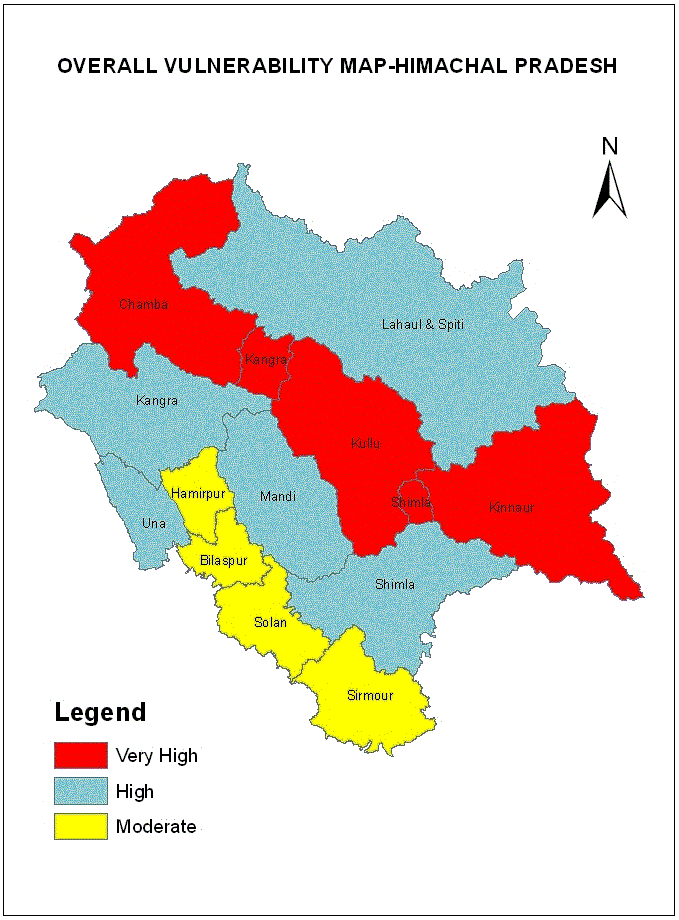
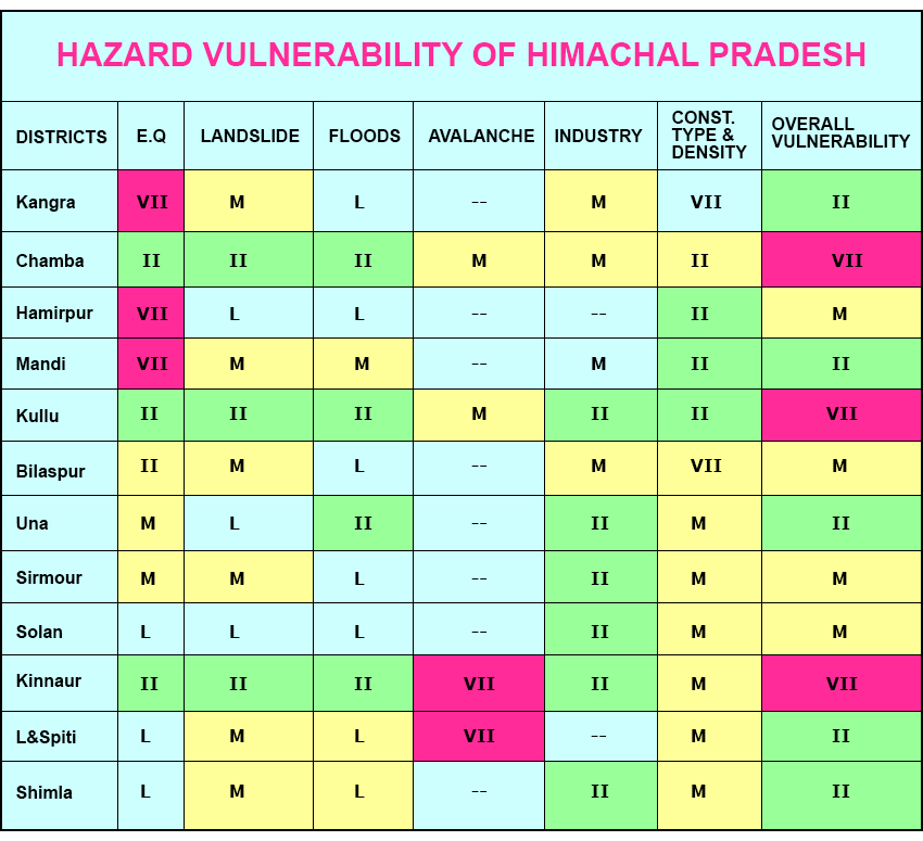
Considering the proneness of the state towards different kinds of natural hazards, a broad district wise vulnerable status was devised for the state depending upon the vulnerability towards different hazards. Vulnerability matrix was developed based on the qualitative weightage which was given in the scale of 0-5 for different hazards such as earthquakes, landslides, avalanches, industrial hazards, construction type and density of population. District wise matrix was prepared by evaluating the risk severity. The evaluation also gives weightage to the density of population likely to be affected. The matrix also includes the evaluation of hazards likely to be induced on account of development of projects such as hydel projects, roads industries etc.
In case of earthquake vulnerability, the district Kangra ,Hamirpur and Mandi falls in very high vulnerable category on the basis of the matrix devised. The districts which falls in high earthquake vulnerability are Chamba, Kullu, Kinnaur and part of Kangra and Shimla districts, where as the moderate and low vulnerable districts are Una, Bilaspur ,Sirmour and Solan,Shimla and Lahaul & Spiti districts respectively.
The landslide vulnerability in case of Chamba, Kullu, Kinnaur and part of Kangra and Shimla districts is high followed by Kangra, Mandi, Bilaspur, Shimla,Sirmour and Lahaul & Spiti districts falling in moderate vulnerable category.The areas falling in low vulnerable category are in the districts of Una, Hamirpur and Solan.
The avalanche hazard vulnerability map suggest that the districts of Lahaul & Spiti and Kinnaur are very high vulnerable followed by Chamba, Kullu and part of Kangra and Shimla as moderate vulnerable areas where as the remaining districts fall in the category where avalanche hazards are nil.
The flood hazard vulnerability map indicates that the areas falling in the districts of Chamba, Kullu ,Una and Kinnaur falls in high vulnerable districts where as the Lahaul & Spiti, Mandi, Shimla , Kangra,Hamirpur, Bilaspur, Solan and Sirmour falls in moderate and low vulnerability areas.
The overall vulnerability of the state on the basis of the matrix clearly suggests that the district Chamba, Kinnaur Kullu and part of Kangra and Shimla falls in very high vulnerable risk. Similarly district Kangra, Mandi, Una ,Shimla and Lahaul and Spiti falls in high vulnerable risk status. The district Hamirpur, Bilaspur, Solan and Sirmour falls in moderate vulnerable risk status. The disaster management strategies and infrastructure required to be evolved by taking the above factors into consideration.
Overall Vulnerability Map of Himachal Pradesh